Posts: 727
Threads: 202
Joined: Jan 2015
As my thread title suggests, this prediction is based purely on sourced online data. I have been told, before any method of prediction can be validated, it has to be repeated several times to negate the possibility of coincidence. For this reason, I have decided to put ACE on the stand again rather than determine position with my own data. Unfortunately, without supervision to prove otherwise, these are just meaningless words, but without an "honest" scientific approach", there would be no point to the following prediction. This will be my last attempt for a while, so I have made a concerted effort to include latitude, though I must stress, probability of success is very low. Longitude is the main focal point of this exercise, latitude has been determined by unproven unconventional means which is still work in progress.
Luzon Island, Philippines ............................ 121'E long by 12' 30' N lat
Off coast of Guyana ................................... 57' 20' W long by 7' 30' N lat
Southern Algeria ........................................ 4' 25' E long by 23' 20' N lat
Sierra Nevada Mountains ............................ 119' 27' W long by 38' 30' N lat
Canary Islands ........................................... 17' 44' W long by 28' 10' N lat
West of the South Sandwich Islands ............ 42' 40' W long by 54' 30' S lat
This prediction will run until 00:00 ut 10th July, Magnitude definitely undetermined with online data, so I will continue with my usual 5 - 6.5 forecast, and a +/- 3' margin of error on both counts. I will update as necessary should any relevant data appear online.
I have been trying to forge an understanding of space data, through the many hours of analysing my own, from my perspective they have correlation, hopefully, if there is any acceptable degree of success with this prediction, it may shed more light on the other !!.
I have to take a leave of absence for the present to concentrate efforts elsewhere, so I'll finish with the unusual step of dedicating one of these locations to my mother as a probable event on 20th June, she follows the quake lists for my benefit, and she will be 79 on this date. I never know what to get her for her birthday, but at least this year, I will be able to tell her I scoured the earth to find her something different ... an honest scientific approach  .
Thank you
Duffy
Posts: 727
Threads: 202
Joined: Jan 2015
(06-18-2016, 03:13 PM)Duffy Wrote: As my thread title suggests, this prediction is based purely on sourced online data. I have been told, before any method of prediction can be validated, it has to be repeated several times to negate the possibility of coincidence. For this reason, I have decided to put ACE on the stand again rather than determine position with my own data. Unfortunately, without supervision to prove otherwise, these are just meaningless words, but without an "honest" scientific approach", there would be no point to the following prediction. This will be my last attempt for a while, so I have made a concerted effort to include latitude, though I must stress, probability of success is very low. Longitude is the main focal point of this exercise, latitude has been determined by unproven unconventional means which is still work in progress.
Luzon Island, Philippines ............................ 121'E long by 12' 30' N lat
Off coast of Guyana ................................... 57' 20' W long by 7' 30' N lat
Southern Algeria ........................................ 4' 25' E long by 23' 20' N lat
Sierra Nevada Mountains ............................ 119' 27' W long by 38' 30' N lat
Canary Islands ........................................... 17' 44' W long by 28' 10' N lat
West of the South Sandwich Islands ............ 42' 40' W long by 54' 30' S lat
This prediction will run until 00:00 ut 10th July, Magnitude definitely undetermined with online data, so I will continue with my usual 5 - 6.5 forecast, and a +/- 3' margin of error on both counts. I will update as necessary should any relevant data appear online.
I have been trying to forge an understanding of space data, through the many hours of analysing my own, from my perspective they have correlation, hopefully, if there is any acceptable degree of success with this prediction, it may shed more light on the other !!.
I have to take a leave of absence for the present to concentrate efforts elsewhere, so I'll finish with the unusual step of dedicating one of these locations to my mother as a probable event on 20th June, she follows the quake lists for my benefit, and she will be 79 on this date. I never know what to get her for her birthday, but at least this year, I will be able to tell her I scoured the earth to find her something different ... an honest scientific approach  . .
Thank you
Duffy
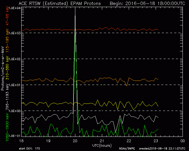
Proton spike at 20:00 ut ... border of terminator dark zone on Luzon, Philippines ... Center of sun at 119' 40' W long!
Calling it as I see it
Duffy
Posts: 727
Threads: 202
Joined: Jan 2015
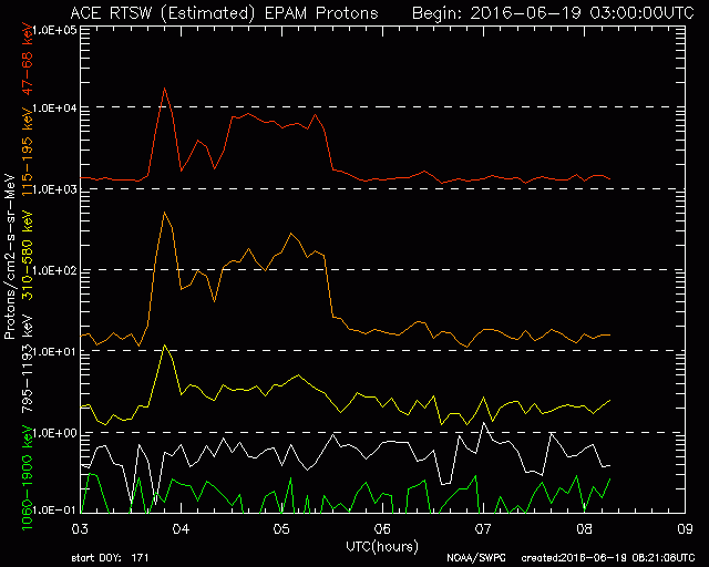
Small proton spike at 03:50 ut ..... Center of sun at 122' 51' E long ... start of structure at 04:20 ut ( shaped like a horizontal rectangle) indicates moon left limb intervention at 80' W long (relative to map), compensate by adding approx 8 (light) minutes, center of sun (relative to map) now at 120' 51' E long.
Start of structure 04:20 ut ... right limb of sun on 121' E long ... center of moon now at 80' W long, distance from center of moon to epicenter of M 6.3 Vanuatu event at 09:47 ut, is equal to length of dark zone at the sun's lateral position (relative to map), or length of night excluding twilight zones at the sun's latitude at 04:20 ut = 23' 26' N ( part of the combination I have been working on ). End of structure at 05:30 ut ... Dark zone border in contact with 119' W - 38' N.
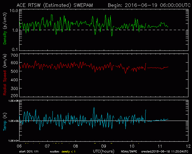
Aspect change at 10:30 ut ... border of daylight and evening civil twilight zone in contact with Luzon Island at 121' E long, the signals are being suppressed due to a possible seismic anomaly somewhere between 50' - 60' South latitude on the civil twilight border. this normally continues for 3 - 4 weeks, location is where the terminator pivots as a result of seasonal changes ; i.e shorter nights North, longer nights South. a useful clue is the sunset time generally remains the same over the period stated. I believe I have located position in my own data, but same indications are not in the satellite data, thus, I cannot include position in this prediction ... I used the same method in "Prediction for SW Indian Ocean 4-4-2016" , on this occassion, position was correct, but I believe it was not deemed significant because it was only a m5.1 event. I would normally refer to this current position as a terminator event (also mentioned in said prediction), a pre seismic anomaly may be sharing the same civil twilight zone as Luzon Island (kind of like channelling energy!!) ... the suppression started on 11th June, several hours after the 5.1 Luzon quake on 10th ... it should cease at approx 20:06 ut, before starting it's daily cycle again tomorrow.
Time is short at the moment, but I will be doing a follow up evaluation after this prediction expires to address any quiries.
Duffy
Posts: 379
Threads: 18
Joined: Nov 2013
(06-19-2016, 01:21 PM)Duffy Wrote: Hi Duffy;
Small proton spike at 03:50 ut ..... Center of sun at 122' 51' E long ... start of structure at 04:20 ut ( shaped like a horizontal rectangle) indicates moon left limb intervention at 80' W long (relative to map), compensate by adding approx 8 (light) minutes, center of sun (relative to map) now at 120' 51' E long.
Start of structure 04:20 ut ... right limb of sun on 121' E long ... center of moon now at 80' W long, distance from center of moon to epicenter of M 6.3 Vanuatu event at 09:47 ut, is equal to length of dark zone at the sun's lateral position (relative to map), or length of night excluding twilight zones at the sun's latitude at 04:20 ut = 23' 26' N ( part of the combination I have been working on ). End of structure at 05:30 ut ... Dark zone border in contact with 119' W - 38' N.
> This is helpful. Do you have a list of date/times for the structures you've been using to make predictions?
> I'm trying to duplicate what you're doing for analysis purposes.
> I can calculate the sun and moon positions. I can also send you a copy of the program so you won't need to fiddle with drawing lines on your screen.
Roger
Posts: 727
Threads: 202
Joined: Jan 2015
Hi Roger
All the data is saved on the monitors and flash drives, to determine the behaviour of predicted anomalies I have to keep pace with the present data, things change week by week, one reason I am trying to record a whole 12 months worth for comparison. At present, I couldn't find the time to go through old data, but I'll try and work something out in the near future. Don't read to much into this prediction yet, it may not live up to expectations, big difference going for five compared to one, and it is still only my interpritation of what I believe is happening. Thanks for the offer of the program, but I've got this far with my old school method ... works for me.
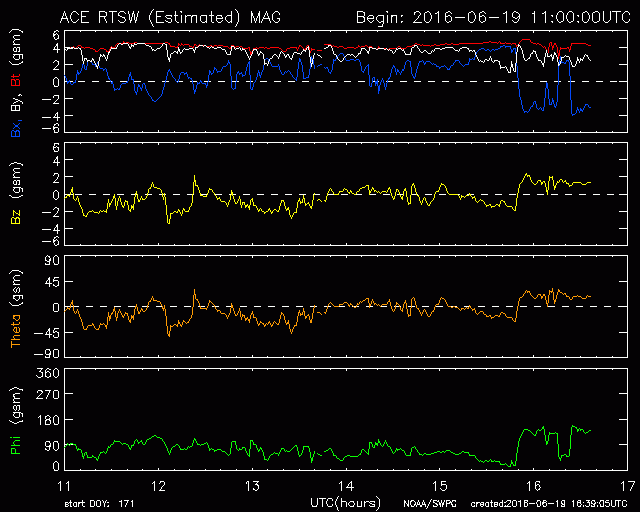
Aspect change in magnetic field 15:48 ut .... center of sun 56' 37' W long (opposite Luzon Island)
Small compression at 16:18 ut .................... right limb of sun leaving 56' W long (last contact)
New aspect change at 16:24 ut (butterfly effect!) .................. Evening dark zone border at approx 7' N lat now within same distance to 56'W, as moon was to Vanuatu.
Duffy
Posts: 727
Threads: 202
Joined: Jan 2015
(06-19-2016, 06:43 PM)Duffy Wrote: Hi Roger
All the data is saved on the monitors and flash drives, to determine the behaviour of predicted anomalies I have to keep pace with the present data, things change week by week, one reason I am trying to record a whole 12 months worth for comparison. At present, I couldn't find the time to go through old data, but I'll try and work something out in the near future. Don't read to much into this prediction yet, it may not live up to expectations, big difference going for five compared to one, and it is still only my interpritation of what I believe is happening. Thanks for the offer of the program, but I've got this far with my old school method ... works for me.
Aspect change in magnetic field 15:48 ut .... center of sun 56' 37' W long (opposite Luzon Island)
Small compression at 16:18 ut .................... right limb of sun leaving 56' W long (last contact)
New aspect change at 16:24 ut (butterfly effect!) .................. Evening dark zone border at approx 7' N lat now within same distance to 56'W, as moon was to Vanuatu.
Duffy
M 5.4 Batan Islands region, Philippines 18:20 ut ... 121' 20' E long by 20'10 N lat ... not bad for old school, think it's just warming up though !!
Duffy
Posts: 727
Threads: 202
Joined: Jan 2015
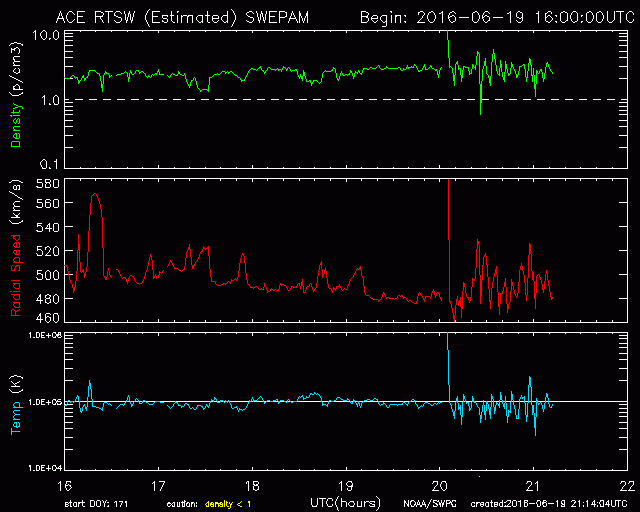
Aspect change at 20:05 ut ... sun at 120' 52' W long, subtract 8 (light) minutes, sun now 118' 52' W long (relative to map). Cross refference of morning / evening terminator at civil twilight border with daylight indicates possible anomaly at 37' S lat by 53' 30' W long Off the coast of Uruguay .. result is preliminary at this point.
In refference to keeping pace with present anomalies, I discovered the terminator pivot I suggested in the Southern hemesphere is actually in the North at bearing 12' 30' N lat, which ironically includes Luzon Island. The sunset time does not change for at least the next five weeks !, I believe the aspect change at 20:05 ut was more prominent than usual because the dark zone border was in contact with Luzon Island shortly after the 5.4 in batan Islands (some kind of residual after affect perhaps). Uruguay shares the same civil twilight zone as Luzon Island, the possible out come could be quite interesting.
Duffy
Posts: 727
Threads: 202
Joined: Jan 2015
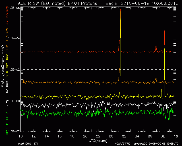
Proton spike at 01:25 ut ... position of moon 18' 22' S lat by 25' 43' W long, moon right limb in contact with 18' West long (relative to map).
Proton spike at 08:15 ut ... morning civil twilight border with daylight in contact with 18' 22' S lat by 25' 43' W long, same point the moon occupied at 01:25 ut !
Duffy
Posts: 727
Threads: 202
Joined: Jan 2015
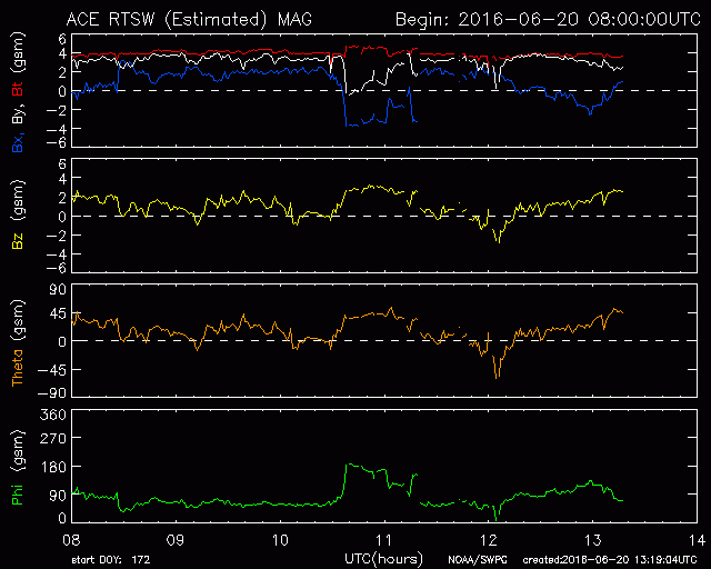
Aspect change at 10:36 ut ... the border of evening civil twilight zone in contact with 20' N lat by 121'E long, approx same location as m5.5 Batan Islands event yesterday (19th).

Aspect change at 12:00 ut ... the border of evening dark zone in contact with 20' N lat by 121' E long, seems to imply focus has changed to this location, terminator contact at moon location point earlier in the day, and this current data could be suggestive of a possible link. This is still my interpritation of the data, otherwise it is coincidental that aspect changes occurred North of the focal point of this prediction, in the area of a notable seismic event !!. This may also give an insight into why I started modifying my predictions ... so much for a daily cycle !, see how long this one lasts.
Duffy
|
 .
. .
. Logout
  Portal
  Forum
Forum Search
 Members
 Help
Help 
