Posts: 727
Threads: 202
Joined: Jan 2015
I returned home from work yesterday, and discovered my systems had been scrambled, they had also re-started in default mode, both Maglev's had destabilised and broadband was off line. We had experienced a lot of lightning during the day so I assumed this was the likely cause, which is contrary to belief in my household that I blame everything on seismic anomalies. This morning, I noticed disruption had occurred with the proton / electron monitors in the ACE data ... though my own data had been wiped, I did a positional calculation of the space data and determined a possible longitude. Ironically, positional calculation of the time the Maglev's went off landed within the same longitude parameters, so I have decided to make a prediction on this basis to see if ACE points the way
This prediction is for a mag 5 - 6.5 at 42' W long , ( North Atlantic ridge) or 138' E long ( Philippine Sea) +/- 3' ... as before, named locations are mainly for reference.
Thank you
Duffy
(23:35 ut)
Posts: 727
Threads: 202
Joined: Jan 2015
(06-08-2016, 11:35 PM)Duffy Wrote: I returned home from work yesterday, and discovered my systems had been scrambled, they had also re-started in default mode, both Maglev's had destabilised and broadband was off line. We had experienced a lot of lightning during the day so I assumed this was the likely cause, which is contrary to belief in my household that I blame everything on seismic anomalies. This morning, I noticed disruption had occurred with the proton / electron monitors in the ACE data ... though my own data had been wiped, I did a positional calculation of the space data and determined a possible longitude. Ironically, positional calculation of the time the Maglev's went off landed within the same longitude parameters, so I have decided to make a prediction on this basis to see if ACE points the way
This prediction is for a mag 5 - 6.5 at 42' W long , ( North Atlantic ridge) or 138' E long ( Philippine Sea) +/- 3' ... as before, named locations are mainly for reference.
Thank you
Duffy
(23:35 ut)
Apologies, forgot to add a termination date ... 00:00 ut on last day of this month sounds ok.
Posts: 727
Threads: 202
Joined: Jan 2015
Over the past few weeks, I have been trying to establish a positional combination between all seismic events above magnitude 5, it's a little to early to go into much detail yet as I am still trialing it. However, the pattern broke after the Luzon, Phillipines quake last Thursday (9th June), been trying to find out why, but it has left me with an observational conundrum which also includes ACE data, and the reason why it's posted here. The following is a series of images which have no correlation to my own recordings but seem to be oddly coincidental to each other. There are 8 images in total, so I may have to do this in two parts.
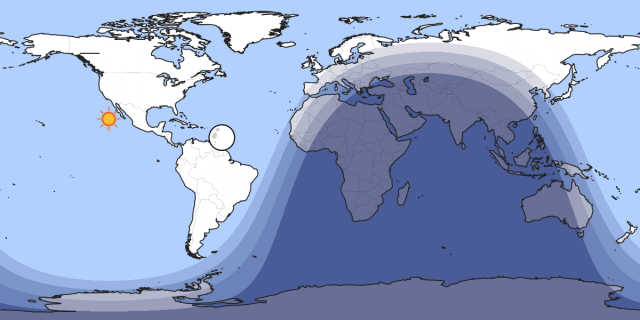
This map relays position of the sun and moon when an m5.3 occurred on Luzon Island, Phillipines at 19:54 ut on 9th June. Nothing significant on this map, it's just the starting point of my lost link ... for those unfarmiliar with the location of Luzon Island, it will soon become apparant in the next images.
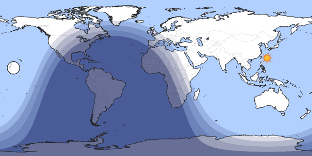
10th June 03:26 ut m6.0 Nicaragua .... Note the sun's position at this time, Luzon Island is below left relative to the maps longitude.
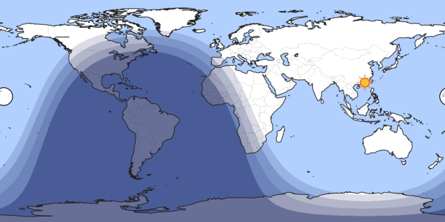
10th June 04:18 ut m6.1 Solomon Islands ... Luzon Island is now below right of the sun !
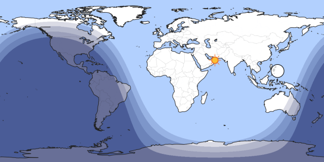
10th June 08:04 ut m5.2 Southern California ... The left limb of the moon is on the same longitude as Luzon Island !!
Up to this point, the earthquakes listed here all occurred in the same sequence shown.
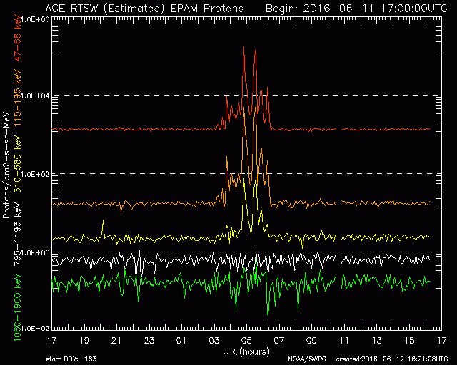
This image was taken from the ACE site on 12th June ... Unfortunately, I missed my chance to recover the 6 hour window version so a little zooming may be nessesary, you can ignore the signal structure, the break in the signal at 10;40 ut is the point of significance here.
Continued in next post ........
Posts: 727
Threads: 202
Joined: Jan 2015
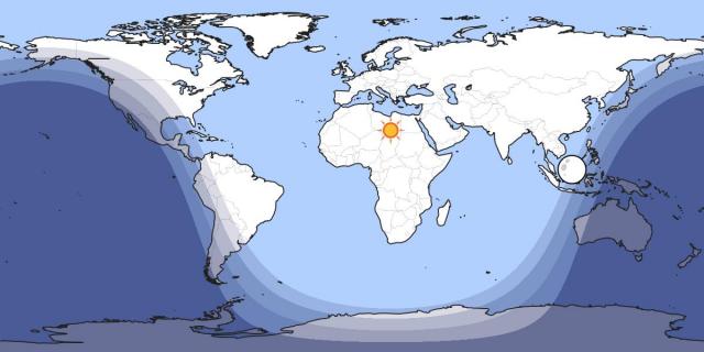
This map shows the right limb of the moon on the same longitude as Luzon Island, the time is 10:40 ut .. it represents the moon's position relative to the ACE image.
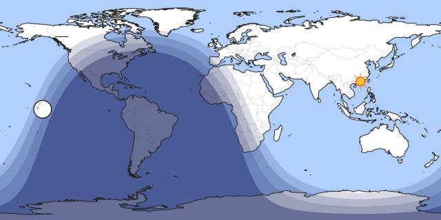
Today ( 13th June ) 04:22 ut m5.6 South-East of Ryukyu Islands ... and the sun is ???
As I have not seen anything in my own data, I am unsure if this means anything significant, it's a classic positional determination in respect of how I find longitude for my predictions .. left limb of sun = first contact, right limb = last contact. I remember trying to explain this to Roger months ago (during my hypothermic attack), ordinaraly, I would suggest this may indicate an anomaly residing at 121' E longitude, or possibly 59' W as my prediction method implies. One other clue I came across was an eruption alert on the volcano discovery web site, it relates to Bulusan volcano on Luzon Island, it currently has alert level 1 status, with a 4 kilometer PDZ, a sudden eruption occurred at 11:35 local time (02:30 ut) on the 10th June, Alert level 1 is nothing to worry about, but it does give thought to alternate eruption theories. Without sufficient data, all this is pure speculation ... but 121' E longitude does seem to be acting like a channelled conection to other seismic anomalies, or are the orbital positions simply a big coincidence ?.
Thank you
Duffy
Posts: 727
Threads: 202
Joined: Jan 2015
A mag 5.0 occurred today at 17:41 ut on the Western Indian-Antarctic Ridge, at longitude bearing 139' 32' E ... this confirms a longitude detection of a seismic anomaly is indeed possible by sourcing readily available online data. This also confirms, the Maglev's are responding to seismic pulses of an undetermined nature " which is not within my locality". I shall keep this prediction running it's term, as activity at 42' W appeared on my screens two days ago. I don't think we currently have any satellites named "full house" but perhaps there's one slated for launch in the near future  .
Forgive my humour .. thought I would add a little in case people were "actually" considering I might know what I am talking about !!.
Duffy
Posts: 727
Threads: 202
Joined: Jan 2015
(06-13-2016, 08:18 PM)Duffy Wrote: A mag 5.0 occurred today at 17:41 ut on the Western Indian-Antarctic Ridge, at longitude bearing 139' 32' E ... this confirms a longitude detection of a seismic anomaly is indeed possible by sourcing readily available online data. This also confirms, the Maglev's are responding to seismic pulses of an undetermined nature " which is not within my locality". I shall keep this prediction running it's term, as activity at 42' W appeared on my screens two days ago. I don't think we currently have any satellites named "full house" but perhaps there's one slated for launch in the near future  . .
Forgive my humour .. thought I would add a little in case people were "actually" considering I might know what I am talking about !!.
Duffy
M5.6 Papua, Indonesia 14 / 6 / 2016 22:09 ut ......... 137' 56' E !
Duffy
Posts: 727
Threads: 202
Joined: Jan 2015
An M 6.1 occurred today at 16:26 ut on the Northern Mid-Atlantic ridge bearing 45' 23' W longitude, it's a fraction outside my margin of error but it is still within the opposite longitude range this prediction set out to achieve. Considering my limited resources I think this was a successful demonstration in the ability to determine longitude of a potential seismic event using online data. I am not so naive as to think only I know this, there are professionals watching this kind of data 24/7, however, why is it not mentioned in current seismic research papers ?, why is it not included in quake related programs on TV ? why has nobody indicated the numerous small breaks in the SWEPAM data relate to anomalous earth pings on the terminator ?. I would love somebody to tell me I'm not the only one !. ... I am using a dodgy broadband connection, and a crappy felt pen, have I wasted my time on this ?.
Here's another conundrum related to this M 6.1 event, I recently added it to my combination as it has now occurred three times in two months;
21:16 ut 20th June ......... Position of sun = 138' 33' W Position of moon = 46' 39' E
138' 33' add 46' 39' = 185' 12' Lateral distance of sun and moon
185' 12' divided by 2 = 92' 36'
sun position 138' 33' minus 92' 36' = 45' 57 W long
The M 6.1 quake today occurred at 45' 20' W long
The last Maglev notification was for 21:16 ut 20th June !!!
This also works with the moon
This combination I refer to as " tug of war" , I did add "of the world's" on the end, but it sounded tacky! There are obviously variables to take into account; was the time actually 21:15:40 ut, or the fact that the maglev time is reliant on analogue clocks makes true time unreliable etc. The sun and moon had reached a point in their respective orbits, where they both simultaneously instigated an influence on an anomaly at position referred to above, that we now know resulted in a M 6.1 . Could this be viewed as coincidences ? from my perspective "no" , The maglev's were partly responsible for achieving the first part of this prediction, "tug of war" has happened twice before on un-predicted anomalies. The data fits the picture ... The maglev notification is on record ... the prediction is on record, and the event is on record, my current prediction is running under the same parameters as this one did, and is not being influenced with my own data, to-date, it has two longitude hits which means more success for ACE.
It occurs to me .. if seismologists are not currently utilising space data in there quest for answers, they should do so, and somebody should tell the people at the SWPC in Bolder, Colorado that their satellite is defective ..... should it not be looking at the sun  .
Thank you
Duffy
|
 Logout
  Portal
  Forum
Forum Search
 Members
 Help
Help 

 .
. .
.